The Crown land 2031 State Strategic Plan (PDF, 3.7 MB) vision for NSW is that our community has high aspirations to derive better value from public land to support resilient and prosperous communities. This includes prioritising the identification, protection, and expansion of environmental assets on Crown land, as well as expanding green and open space and promoting activities that build climate resilience.
There is a wide range of tracks and trails across NSW Crown land. Each year hundreds of thousands of walkers enjoy the tracks and trails we manage. We are maintaining the trails for walker safety and enjoyment so our community can be confident that our trails are being actively managed to maintain or improve safety and enjoyment.
The following projects are funded by the NSW Government to keep the trails in a safe condition and renew some aging visitor infrastructure including steps, toilets, and track surfaces.
Walkers may be inconvenienced during the works with minor track diversions in place. Please obey any signage on site. If you are planning a long-distance walk, phone 1300 886 235.
Current projects
Summary
- Location: Hume and Hovell Track between Blowering Dam and Albury
- Project investment: $820,000
- Dates: March 2025 to November 2025
With thousands of visitors each year, the Hume and Hovell Track is one of Australia’s most iconic walks—where history, adventure, and breathtaking landscapes come together.
To make this legendary trail even better, the NSW Government is rolling out a series of upgrades to enhance accessibility, comfort, and safety for all adventurers.
Through the Hume and Hovell Capital Works Program, we’re enhancing key sections of this historic trail to create an unforgettable outdoor experience.
Focusing on popular areas between Blowering Dam and Albury, these upgrades will improve essential infrastructure, making it easier for walkers to immerse themselves in the beauty of the landscape while ensuring the track’s natural surroundings remain protected.
We’re working hand-in-hand with key partners, including Forestry NSW, to keep things moving smoothly and ensure all necessary approvals are met.
We value the community’s connection to this track and are committed to keeping you informed. Regular updates on progress, upcoming works, and any temporary changes will be shared through the Crown Lands website and other communication channels.
These works align with the Crown Lands 2031 strategic plan, which prioritises strengthening community connections with Crown land and expanding and improving green space.
Stay tuned and get ready to experience the Hume and Hovell Track like never before!
If you are enjoying the track while works are in progress, please follow any instructions from staff or signage.
Program of works
These upgrades will ensure that the Hume and Hovell Walking Track remains one of NSW’s most breathtaking and accessible long-distance hikes.
Projects include:
New hiker huts – rest in comfort
- Lankeys Creek Camp – A brand-new hiker hut is coming, offering better overnight accommodation for weary walkers.
- The Junction Camp – Another brand-new hiker hut to elevate the camping experience.
- Ben Smith Campground – A new hiker hut will complement the campground’s upgrades.
- Browns Campsite – Subject to funding and approvals, a new hiker hut is planned to give adventurers a cozy retreat.
- Blowering Dam Campsite – Get ready for a new hiker hut alongside other exciting improvements.
- Micalong Creek Campsite – A new hiker hut will offer a welcoming rest stop for those on the trail.
Enhanced campgrounds and facilities
- Ben Smith Campground – A full revamp! Expect new toilets, a water tank, tables, and a realigned 1.2 km section of the track for a smoother hiking experience.
- Blowering Dam Campsite – A fresh toilet, BBQ, and table to enhance comfort and convenience.
- Buddong Hut Campsite – A brand-new toilet will improve sanitation facilities.
- Munderoo and Lankeys Creek Campsites – New tables to create better rest spots along the way.
Bridges and accessibility upgrades
- Albury Council land – Two bridges near the end of the track will be replaced to improve access and safety.
- Norm Harris Suspension Bridge – A much-needed refurbishment will ensure this iconic bridge remains safe and accessible.
Wayfinding and navigation
- New signage plan – Improved wayfinding signage will be installed along the track, making navigation easier for all adventurers.
To speak to an officer
Contact us and quote Hume and Hovell Track Capital works program.
Completed projects
Gosangs Tunnel and Mermaids Inlet, Abraham's Bosom, Currarong were closed in June 2022 due to potential geological risks. This project aimed to ensure public safety through various remedial actions.
Summary
- Location: Currarong
- Project investment: $694,000 including GST
- Dates: April 2024 to September 2024
What was done
- Rock bolting, propping, signage, fencing, and scaling to mitigate geological risks.
- Ongoing inspections to ensure the safety and effectiveness of these measures at Gosangs Tunnel and Mermaids Inlet.
What was gained
- Gosangs Tunnel was reopened, and ongoing inspections will ensure the safety and effectiveness of the mitigation measures.
- Value for money with long-lasting benefits, reducing the need for regular funding requests to safeguard risk management at the site.
- Safety precautions for contractors, the community, and the environment during remediation.
- Economic growth through the reactivation of the popular destination which supports local tourism.
To speak to an officer
Visit the contact us page and refer your enquiry to the Gosangs Tunnel and Mermaids Inlet reopening project.
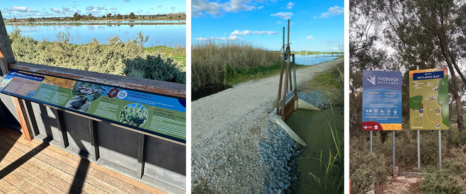
The Fivebough Wetlands Reserve maintenance project is a commitment to preserving the area's natural beauty and cultural heritage. This year's focus includes essential repairs and educational enhancements.
Summary
- Location: near Leeton, NSW
- Project investment: $651,000
- Dates: May 2024 to September 2024
What was done
- Removal and replacement of damaged stock fence.
- Resurfacing and erosion repair of the north walking track.
- Installation of new navigational and educational signage.
What was gained
- Enhanced preservation of natural beauty and cultural heritage.
- Improved safety and accessibility of walking tracks.
- Increased educational value through new signage reflecting Aboriginal heritage.
- Collaboration with local Aboriginal community and artists.
To speak to an officer
Visit the contact us page and refer your enquiry to the Fivebough Wetlands Reserve upgrade project.
Location image
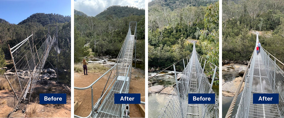
The Bowtells Swing Bridge Refurbishment project is a significant initiative aimed at enhancing the safety and accessibility of the Six Foot Track, a historic 46-kilometre walking trail between Katoomba and Jenolan Caves. The bridge, which serves as a crucial river crossing along the trail, was closed in March 2023 when an engineering assessment indicated the need for immediate replacement due to the original design experiencing cable wear beyond the acceptable Australian Standards.
Summary
- Location: Cox’s River, Six Foot Track (between Jenolan and Katoomba, NSW)
- Project investment: $970,000 excl. GST
- Dates: May 2024 to September 2024
What was done
- Replaced most of the components of Bowtells Swing Bridge to improve safety and retained the bridge towers to preserve the bridge's original character.
- Transitioned the bridge span design from a V-shaped to a U-shaped configuration to improve visitor experience.
- Upgraded anchor and cable sizes for increased stability and capacity, allowing up to 5 people to access the bridge at a time.
- Ensured minimal disruption for walkers as a reroute remained available during the project.
What was gained
- Enhanced safety for walkers by renewing the asset to provide a functional and safe crossing of the Coxs River.
- Improvements to Bowtells Swing Bridge ensure the design is aligned with relevant Australian Standards (AS 2156).
- Improved the overall experience of the iconic Six Foot Track while maintaining the heritage and community value of the asset.
To speak to an officer:
Visit the contact us page and refer your enquiry to the Bowtells Swing Bridge Refurbishment project.
Location image: