Crown land 2031 State Strategic Plan (PDF, 3.7 MB) vision for NSW is that our community has high aspirations to protect environmental assets, improve and expand green space, and build resilience to climate change. Our remediation projects aim to restore and rehabilitate degraded or damaged Crown land sites, addressing contamination and restoring natural built and structural features to make them suitable for community use and enjoyment.
Current projects
During the 2022–23 financial year, Crown Lands checked the condition of sites they manage directly. Sixty of these sites were found to be in poor or very poor condition.
This project aims to open opportunities for future community use of Crown land. By clearing these sites, we can create spaces that can be repurposed for various community projects, potentially boosting local economies and creating green spaces that help both the environment and the community.
Summary
- Location: Various sites across NSW
- Project investment: $955,000 excl. GST
- Dates: Late 2024 to September 2025
- Times of work: Weekdays 7 am to 6 pm
- Traffic and pedestrian changes
- Noise levels: High at times
What we will be doing
From late 2024 you may notice us:
- Conducting environmental and risk material inspections and surveys
- Safely disconnecting and capping all services connected to the structures
- Demolishing and removing unsafe structures, improving the streetscape, and making areas safer and more pleasing to look at
- After demolition, levelling the sites and adding 10mm topsoil/fill to support natural regrowth.
Individual site information:
- Site: 9 Henrys Road, Burrangong
- Action: Demolish and dispose of existing structures, concrete slabs, piers, small surrounding structures, footings, and miscellaneous building waste. Reinstatement of the site to match the existing levels and grade.
- Site: 2 Adelaide Street, Awaba
- Action: We will remove all unsafe and rundown structures, including the access ramp and railings, the covered concrete area, retaining walls, footpaths, and concrete stairs.
- Site: 12 High Street, Bunnan
- Action: We will remove all unsafe and rundown structures, including all footings and slabs, outdoor undercover area, water tank and water tank stand, septic tank, and all other structures/items found on site.
- Site: 1 Dawson Street, Coonabarabran
- Action: We will remove the concrete block structure located at the rear of the property, ensuring the site is cleared and safe.
- Site: 2237 Salisbury Road, Salisbury
- Action: We will remove the existing main structure, 5 outbuildings, and associated structures. This includes concrete slabs, water tanks, and footpaths. We will also remove timber fencing at the front and right of the property.
- Site: 79 Twiggs Road, Maryvale
- Action: We will remove all unsafe and rundown structures, including the concrete footpath. The works do not include the Rural Fire Service (RFS) building, storage shed, tank at the rear of the site, or the reserve fencing.
- Site: 136 Clarkes Creek Road, Windeyer
- Action: We will remove all unsafe and rundown structures, including water tanks and stands.
- Site: 117 – 133 Hunts Road, Gunnedah
- Action: We will remove all unsafe and rundown structures, including tank bases and slabs.
- Site: Lot 7315 - DP 1154181, Hargraves
- Action: Demolish and dispose of existing structures, concrete slabs, piers, footings and miscellaneous building waste.
- Site: 1062 Oxford Falls Road, Oxford Falls
- Action: Demolish and dispose of existing structures, concrete slabs, piers, footings, and miscellaneous building waste.
What you can expect
- Opportunities for future community use of Crown land
- Prevention of illegal access and occupation of the sites
- Creation of green spaces that help both the environment and the community.
Keeping up to date with our work
We will update this page as the project progresses.
To speak to an officer
Visit the Contact us page and quote "10 Crown land sites demolition and rehabilitation".
Summary
- Dates: June to September 2025
- Times of work: Weekdays 7 am to 5 pm
- Noise levels: Medium. Potentially noise-generating works will be conducted between 9 am and 4 pm only.
What we will be doing
- Excavation and removal of concrete hardstand areas and underground sump.
- Excavation, classification, and transport of contaminated soil to a licensed waste facility.
- Levelling of excavation areas.
- Removal of asbestos-containing materials by a licenced asbestos removalist.
- Daily air monitoring tests to ensure standards are maintained.
When we will be working
The site remains fenced off and is not accessible to the general public.
Work will take place during standard construction hours, 7 am and 5 pm, Monday to Friday.
Potentially noise-generating works will be conducted between 9 am and 4 pm only.
What you can expect
- The health and safety of the community is our priority. To minimise the impact of works on the local community, noise, dust, and vibration will be kept to a minimum.
- The site will be remediated using methods proven to be environmentally safe, with clear standards to confirm the clean-up was effective.
- All legislative, local council, and SafeWork NSW requirements for the removal of asbestos-containing material will be met.
- An independent clearance certificate will be obtained to confirm completion of works.
We thank you for your patience and co-operation while we complete this important work.
Keeping up to date with our work
We will update this page as the project progresses.
To speak to an officer
Phone 1300 886 235 or email [email protected]
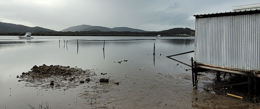
Summary
- Location: Crown Reserve off Crawford Street at Bulahdelah
- Project investment: $385,000
- Dates: May to August 2025
- Times of work: Weekdays 7 am to 5 pm, Saturdays 8 am to 1 pm
- Noise levels: Medium
What we will be doing
- Removing contaminated soil from the site to prevent future impacts on and off the site and to protect the natural environment.
- Removing redundant infrastructure, including parts of the asphalt surface, the damaged wharf, disused fuel storage tank and fuel shed, underground fuel lines, fuel dispenser, and winch storage shed.
- Restoring the site by planting vegetation to ensure bank stabilisation and make it safe for future use, consistent with the RU5 – Village zone, such as recreation, tourist or commercial development.
When we will be working
Work will take place during standard construction hours, 7 am and 5 pm Monday to Friday, and some Saturdays between 8 am and 1 pm.
What you can expect
- Surrounding roads may be temporarily impacted as larger equipment enters and exits the site, but traffic control will be implemented where required in accordance with an approved traffic management plan.
- The project aims to minimise the impact of works to the local community, including keeping noise, dust and vibration to a minimum.
- The health and safety of the community is our priority. All construction activities are in accordance with the approved construction management plans.
We thank you for your patience and cooperation while we complete this important work.
Keeping up to date with our work
We will update this page as the project progresses.
To speak to an officer
Phone 1300 886 235 or email [email protected]
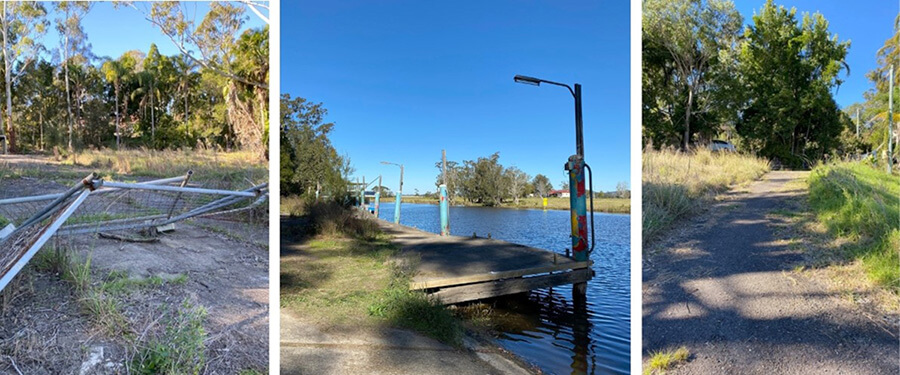
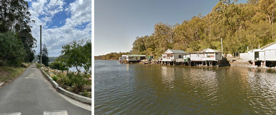
Summary
- Location: Old Ferry Road, Illawong
- Dates: mid-2024 to early 2026
- Times of work: Weekdays 7 am to 6 pm
- Traffic and pedestrian changes: Will remain closed until remediation completed.
What we will be doing
From mid-2024 you may notice:
- Demolition (completed)
- We have completed the demolition of 5 unsafe structures from Crown land, including clearing hazardous materials, old vehicles and overgrown weeds.
- Rehabilitation (mid-2025 to early 2026):
- Comprehensive site recovery to make the area safe and ready for everyone to enjoy.
What you can expect
- Access to the area will be impacted until hazardous materials, including asbestos, have been removed. Please do not enter the site.
- Long-term plan is for the community to benefit from a revitalised Georges River foreshore to enjoy a more scenic and functional riverfront, ideal for relaxation and activities. The remediation works will also improve the condition of Georges River National Park.
Keeping up to date with our work
We will update this page as the project progresses.
To speak to an officer
Visit the contact us page and quote "Illawong Cottages Removal" for any inquiries or further information.
Location image
Summary
- Location: Moonee Beach, NSW
- Dates: June 2025 to June 2027
- Pedestrian changes: No access across Sugar Mill Creek
Completed work
- The removal of the Moonee Beach pedestrian bridge was completed in June 2025.
- The bridge had been closed since November 2022 after an engineering assessment found it was unsafe and beyond repair.
- The Soil Conservation Service removed the bridge for Crown Lands, taking cultural and environmental factors into account.
- The Coffs Harbour and District Local Aboriginal Land Council monitored the process to ensure middens were protected.
What you can expect
- There will be no access across Sugar Mill Creek until a new bridge is built.
- Do not try to cross the creek on foot. Your safety, and Aboriginal cultural heritage may be at risk.
- Water depth in the creek ranges from 30 cm at low tide to over 3 metres at high tide, making crossing dangerous and unpredictable.
- Green Bluff can be accessed from the south via Rutile trail, off Ivory Circuit in North Sapphire.
- If you are planning to do the Solitary Islands coastal walk please find further information on the NSW National Parks website.
- We thank you for your patience and cooperation while we complete this important work.
What happens next
- Design and planning for a replacement footbridge is underway this financial year.
- We’re working with the City of Coffs Harbour, National Parks and Wildlife Service, and Reflections Holidays to secure joint funding.
- We’re working with NSW Public Works to deliver the design and planning phase.
Keeping up to date with our work
We will update this page as the project progresses.
To speak to an officer:
Visit the contact us page and refer your enquiry to the Moonee Beach Pedestrian Bridge project.
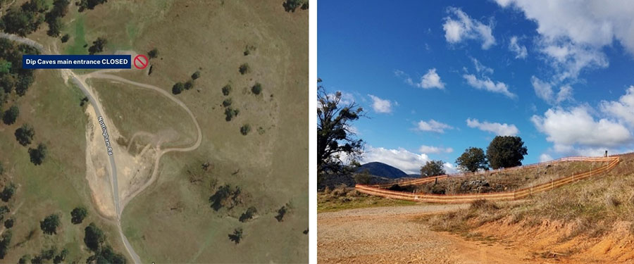
The Wee Jasper Dip Caves include 5 parallel and interconnected caves with multiple entrances. The main walk-in entrance is geologically unstable, and tests have confirmed the presence of asbestos contamination.
Geological instability of the main entrance increases the risk of rock fall and landslips which could result in injury or death. Breathing asbestos fibres increases the risk of serious diseases, including asbestosis, mesothelioma, and lung cancer.
Keep yourself safe and do not use the main entrance leading into the Dip Caves.
Summary
- Location: Wee Jasper Reserves, Wee Jasper
- Dates: ongoing
- Pedestrian changes: no entry to the site as there are safety risks
What we will be doing
- Assessing options that could safely permit the reopening of the main entrance to the Dip Caves for a range of users and interest groups.
- Engaging with the community, stakeholders, and interest groups to support decision-making.
- Considering remedial strategies that are sensitive to the requirements of the vulnerable Bent-winged Bat population and address public safety needs.
- Undertaking further studies to inform any proposed works to stabilise the main entrance and / or remove contamination.
- Implementing remedial works as required.
What you can expect
- Temporary fencing has been installed to restrict access to this site. The main walk-in entrance to the Dip Caves remains closed.
- Temporary fencing at other entrances is to prevent accidental falls into the caves. These access points are not currently closed to the public.
- Fencing measures will remain in place until further investigations can be completed. This is for the safety of our crew, users, and pedestrians.
Keeping up to date with our work
We will update this page as the project progresses.
To speak to an officer
Visit the contact us page and refer your enquiry to the Wee Jasper Dip Caves remediation project.
Location image
Current investigations
Background
- 17 Denison Street Gloucester has a long history of being used for industrial and commercial purposes and was escheated to the Crown estate in 2019.
- Crown Lands and Mid-Coast Council have been working together to investigate the site condition to explore future use options.
- Crown Lands has secured the site and has undertaken further site investigations to determine the extent of potential contamination from the former Service Station and Agricultural Machinery Centre which will guide remediation requirements to rehabilitate the site for the benefit of the community.
Remediation works
- Mid Coast Council completed a Stage 1 and 2 Site Contamination Assessment (PDF, 3.8 MB) investigation in 2022 into the site to determine potential hazards and risks.
- In 2023–24, Crown Lands undertook clean up and make safe works on the premises, including rubbish removal, vegetation management and erecting a fence around the premises.
- The following investigations were conducted to inform the project:
- Next steps will include preparing a scope of works, seeking quotations and securing the required funds to achieve the project objectives.
- Throughout the project, Crown Lands will continue to manage the site, ensuring public safety and environmental protection are a priority.